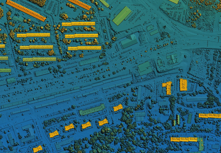
In the realm of geospatial technologies, laser mapping, also known as LiDAR (Light Detection and Ranging), has emerged as a revolutionary tool, transforming the way we perceive and interact with our surroundings. This cutting-edge technology utilizes laser beams to precisely measure distances, enabling the creation of highly accurate and detailed three-dimensional maps. In this blog post, we’ll delve into the intricacies of laser mapping, exploring its applications, benefits, and the transformative impact it has on various industries.
Understanding Laser Mapping
Laser mapping operates on a simple yet sophisticated principle: it sends laser pulses to the Earth’s surface and measures the time it takes for the light to return. By calculating the distance between the sensor and the target surface, laser mapping creates precise and intricate representations of landscapes, objects, and structures. This technology has found extensive use in cartography, forestry, urban planning, archaeology, environmental monitoring, and more.
Applications of Laser Mapping
- Topographic Mapping and Surveying:
Laser mapping is a game-changer in topographic mapping and surveying. Traditional surveying methods often require significant time and resources, but LiDAR can swiftly and accurately capture vast terrains, including challenging or inaccessible areas. This is particularly beneficial for infrastructure projects, city planning, and land management. - Forestry and Environmental Monitoring:
The forestry industry relies on laser mapping for forest inventory, biomass estimation, and monitoring environmental changes. LiDAR can penetrate dense canopies, providing detailed information about the structure and health of forests. This data is invaluable for sustainable forest management and conservation efforts. - Urban Planning and Development:
Laser mapping plays a pivotal role in urban planning by providing detailed insights into the layout and structure of cities. It aids in infrastructure development, flood modeling, and assessing the impact of new construction projects. The high level of accuracy offered by LiDAR enhances the precision of urban planning initiatives. - Archaeology and Cultural Heritage Preservation:
In archaeology, laser mapping has proven to be a powerful tool for mapping archaeological sites and preserving cultural heritage. It enables archaeologists to create detailed 3D models of landscapes and structures, aiding in the documentation and conservation of historical sites. - Disaster Response and Management:
Laser mapping facilitates rapid and accurate assessment of disaster-stricken areas. Emergency responders use LiDAR data to create detailed maps, identify hazards, and plan rescue operations. This technology is instrumental in improving the efficiency and effectiveness of disaster response efforts.
Benefits of Laser Mapping
- High Precision:
Laser mapping provides unparalleled precision in capturing spatial data. The ability to measure distances with millimeter-level accuracy makes it an indispensable tool for applications that demand exact measurements. - Efficiency and Speed:
Compared to traditional surveying methods, laser mapping significantly expedites the data collection process. It allows for the swift acquisition of vast amounts of information, making it a time-efficient solution for various industries. - Versatility:
Laser mapping is versatile and applicable across diverse environments. Whether surveying mountainous terrains, dense forests, or urban landscapes, LiDAR can adapt to different settings, providing consistent and reliable results. - Non-Intrusive:
LiDAR is a non-intrusive technology, allowing for data collection without physical contact with the target area. This non-destructive feature is particularly advantageous in sensitive ecosystems and archaeological sites.
As laser mapping continues to evolve, its impact on geospatial technologies becomes increasingly profound. From enhancing the precision of surveying and mapping to aiding in disaster response and cultural heritage preservation, LiDAR has proven to be a transformative force. The ongoing advancements in laser mapping technology hold the promise of unlocking new possibilities and further expanding its applications, ultimately contributing to a more accurate, efficient, and sustainable understanding of our world.
